
Thursday, June 9, 2016

In Whitehorse near the airport is located what must be the largest weather vane in the world. It is a retired DC-3 mounted on a post. The old plane always points with the wind. We actually saw it move while we were taking the photo.
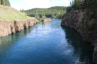
 Two other attractions in Whitehorse are the Klondike, an old paddle boat, and Miles Canyon. We were confused about Miles Canyon until we went there and read the sign. In our mind we were thinking a canyon miles wide or something along those lines. Turns out the name has nothing to do with distance and the canyon is named after a U.S. Army officer with the last name Miles.



Klondike

Miles Canyon
The sled dog training facility we visited yesterday was interesting and we will make a post about that later. Today is moving day and we are headed for Skagway. Time to get the show on the road.
Wednesday, June 8, 2016
The road from Nugget City to Whitehorse continued to charm us with scenery. There were a few long stretches of gravel due to construction but the road was good the majority of the way.
 Our first full day in Whitehorse we visited the Fish Ladder and the Yukon Wildlife Preserve. The Fish Ladder is operated by Yukon Fish and Wildlife and was interesting. Basically it consists of chambers of sequentially connected Yukon River water that increase in elevation allowing the fish to travel from below the dam to above the dam. Of course the reverse is also possible as the Chinook Salmon migrate from the Bering Sea to the Upper Yukon region to spawn. We were told by one of the employees that the Chinook Salmon makes the longest salmon run in the world.


Next are a few of the animals we saw at the Wildlife Preserve.




Fish Ladder facing up river
Inside there are several viewing windows and a live camera feed. They actually count all the male and female salmon as they migrate. We were informed that the salmon were not good to eat once they start the migration because they starve themselves.

We saw a few Grayling and one baby Chinook. The salmon making the migration are still in Alaska and only travel about 30 km per day. The following map shows where they were yesterday.


Elk with velvet on antlers

Mule Deer

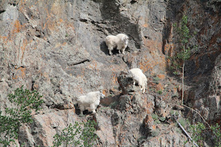
Mountain Goats

Musk Ox
The Musk Ox supposedly has fir eight times warmer than wool. They do not have any blood vessels in the lower portion of their legs. This enables them to endure long periods standing on ice without loosing body heat. As seen from the photo they are quite ugly and we were told very unfriendly. The author has no plans to pet one.

Arctic Fox

Moose
Today we are off to a sled dog training facility and will report on that later.
Tuesday, June 7, 2016
The roadside fuel stop, gift shop, restaurant, and campground at Nugget City was all created by Don and Gwen Lee and their family. Don and Gwen now live in British Columbia but his daughter, who operates the gift shop, told us he built the campground at the age of 91. Don and Gwen married in 1948 and have done everything together since, including prospecting for gold and jade. Gwen wrote a book about their Yukon experience and we purchased a copy.
 A section of a tree that had the largest knot we have every seen was located outside of the gift shop.
 We just had to eat at the "Wolf It Down" restaurant and were not disappointed.

Click on the photo and notice the sign at the left of the door. We have discovered that up here they do not have bathrooms. Instead they are called washrooms. Even in the Walmart the sign reads "Washrooms".
We are now in Whitehorse, the capital of the Yukon, and the only city in the Yukon. At the last census the population was less than 28,000.


Click on the photo and notice the sign at the left of the door. We have discovered that up here they do not have bathrooms. Instead they are called washrooms. Even in the Walmart the sign reads "Washrooms".
We are now in Whitehorse, the capital of the Yukon, and the only city in the Yukon. At the last census the population was less than 28,000.
Monday, June 6, 2016
Friday we left Dawson Creek and started our journey on the Alaska Highway. As we got farther away from Fort St John the scenery became more natural and void of man made structures.

We spent the night at a campground in Fort Nelson that was complete with a restaurant. Over the bar area of the restaurant a few stuffed animals stare down at the patrons. One is a badger and we were told by an employee that the badger was the only animal that a bear would not mess with.
 It was a short walk over to the museum located next door to the campground. This museum is not what usually comes to mind when one thinks of a museum. No paintings on the wall or artifacts from ancient ruins. It was like a "man cave" on steroids with countless old cars, obsolete machinery, stuffed animals of all types, old outboard motors, and the list goes on and on. There was even an old oil rig out in the back. We got the impression that many of the items were donated to the museum.
 The theme of one building was old telephone and electrical test equipment. The photo below shows some of the items located in that building and it was interesting to Pam and I both. Some of you know that Pam retired from the telephone industry.

Leaving Fort Nelson Saturday morning we noticed that the scenery continued to improve. This photo depicts some of the views from our windshield.
 Along the way we stopped at a roadside establishment noted for good cinnamon buns. We may overdose on sugar if we keep finding home baked cinnamon buns.
 Moving on up the Alaska Highway we came to Muncho Lake and more breath taking views.
 Pam was barely able to take a photo of some mountain goats as we passed them by.
 Here is another typical view as we motor down the Alaska Highway.
 The travel day ended at a campground near Liard Hotsprings. We haven't had any cell service since leaving Fort Nelson and this campground was advertised to have WiFi, a phone, and a restaurant. The restaurant was closed and the WiFi was no longer available. They had a business phone but would not allow us to use it. We got an early start and struck out for Watson Lake.
The bears were very active Sunday morning as we drove along. We must have seen 8 or more eating the vegetation in the clearings on either side of the highway. They were so intent on eating that we were not able to get a decent head shot. Look close in the following photo and you can see the vegetation in the bears mouth.
 There were several juveniles and here is a close up of one.

The following three photos show what it looks like to the driver of a big motorhome negotiating steep grades mixed with curves. Sure hope those brakes work!


We finally made it to the Yukon and Watson lake. The Alaska Highway actually meanders into the Yukon for a few miles and then back into British Columbia before crossing back into the Yukon near Watson Lake. As we continued our journey on to Whitehorse today we once again drifted back into British Columbia for awhile. The aspen trees change in appearance almost instantly when you first enter the Yukon. Pam inquired about that when we reached Watson Lake and was told it was because the temperatures were colder this far north.

 Watson Lake is a small community with a population of about 800. It is famous for the Sing Post Forest, the name given to a collection of thousands of signs placed here by travelers just like us. A soldier helping to build the highway placed the first sign here and as others imitated him the signs multiplied and the number continues to grow today.


We spent the night at a campground in Fort Nelson that was complete with a restaurant. Over the bar area of the restaurant a few stuffed animals stare down at the patrons. One is a badger and we were told by an employee that the badger was the only animal that a bear would not mess with.


The bears were very active Sunday morning as we drove along. We must have seen 8 or more eating the vegetation in the clearings on either side of the highway. They were so intent on eating that we were not able to get a decent head shot. Look close in the following photo and you can see the vegetation in the bears mouth.


The following three photos show what it looks like to the driver of a big motorhome negotiating steep grades mixed with curves. Sure hope those brakes work!

Hill ahead

Going down the hill

Whats around the curve


The entrance to the forest

Our sign in the forest
We landed at Baby Nugget RV Park just west of Watson Lake for the night. This is an interesting place ran by a hardy family. More on that later. We are about to head out in the car to explore Whitehorse.
Wednesday, June 1, 2016
Today, with the exception of Rich and Joan, we all made it to downtown Dawson Creek and the infamous "Mile Zero" marker. Rich and Joan had already toured the area since they arrived several days before the rest of us. We plan a photo with everyone at the mile marker sign near the museum. The actual mile marker is in the middle of an intersection making group photos somewhat perilous. For that reason the town of Dawson Creek erected a "Mile Post" sign at the museum not far away. Seven of us did venture out into the street to have our picture taken at the actual mile marker zero.


How long has it been since you used a pay phone? Here is Craig pretending to use the pay phone.

After walking around downtown and touring the museum we hopped back into our vehicles and drove up the Alaska Highway to find the famous curved wooden bridge. The bridge is located on a portion of the highway that is no longer used and has been replaced with a shorter route.

The following photo shows how scenic the old highway can be as one meanders down the road. Up ahead is Craig, Angie, and Van. Tom, Paula, Pam, and I follow in another vehicle.

A view of the bridge.

View from the bridge.

We could have visited the bridge on our way north Friday but all our motorhomes exceed the weight limit of the bridge. The bridge is only a short drive from Dawson Creek so we chose to use our cars for the visit.
We finally arrived at Dawson Creek British Columbia yesterday afternoon, May 31. Dawson Creek is mile zero of the Alaskan Highway and the location where everyone agreed to meet on June 1st. Because several of the original participants had to cancel making the trip, only one other couple, joined us here. With the addition of Rich and Joan from Oregon, we are now five RV's strong. As we continue up the highway there may be times when we will need to break into smaller groups due to limited campground accommodations.

 Four plus 1
 Will make 5.
We are heading out for Dawson Creek and some of the local sites and will post about that letter.


We are heading out for Dawson Creek and some of the local sites and will post about that letter.
Subscribe to:
Posts (Atom)