Yesterday we did a 1.5 hour tour of the Boeing plant in Everett Washington. Cameras, cell phones, knives and weapons, or any electronic devices were not allowed on the tour. The same entry requirements are in place at most of the facilities in Oak Ridge where I worked for 40 years. We felt right at home and that is why there are no photos in this post.
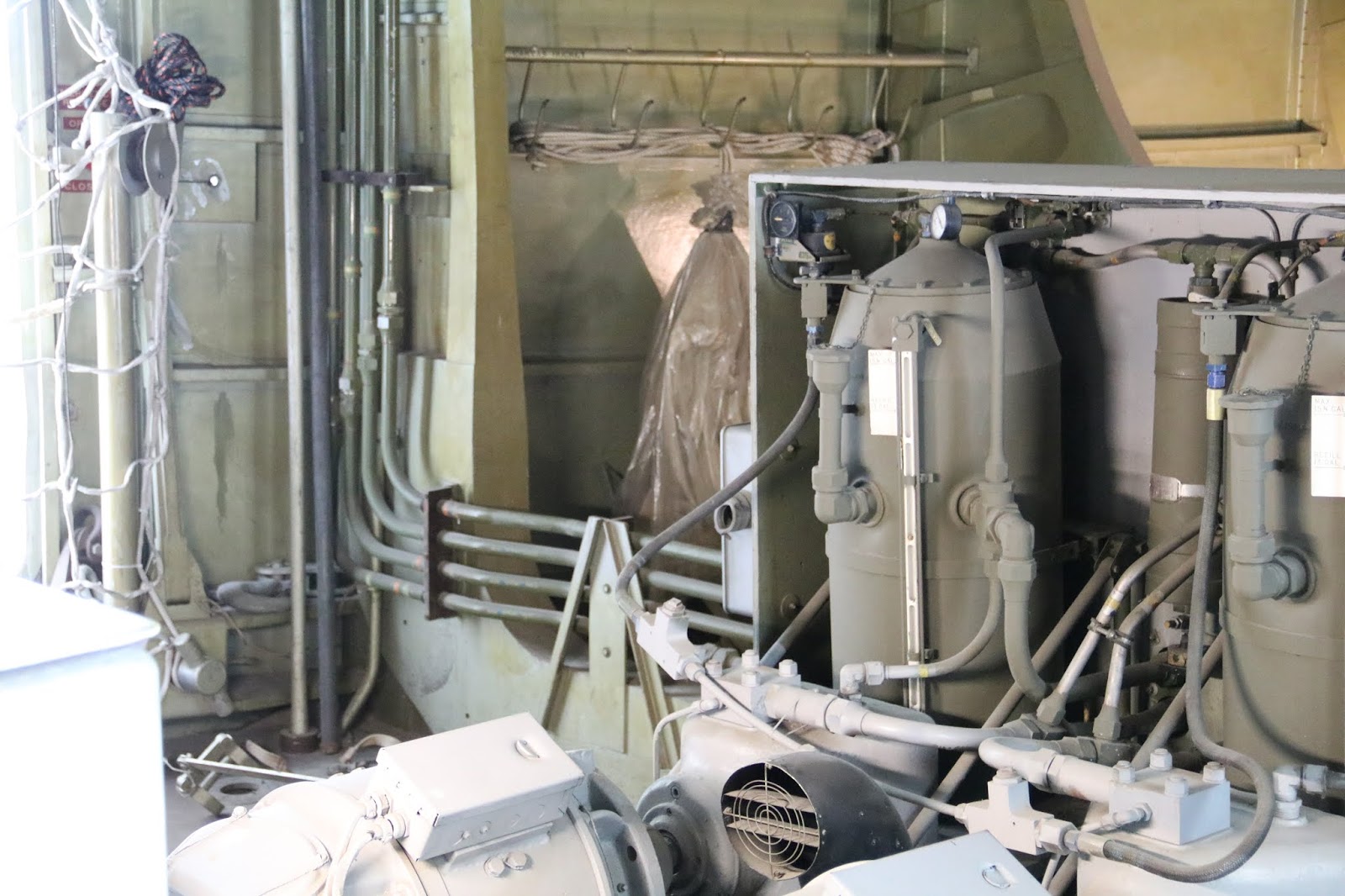
Boeing has manufacturing facilities in many locations with the original being south of Seattle. When Boeing was awarded a contract by Pam American Airlines in 1966 to build 25 747's they needed more space; they only build planes that have already been sold. The facilities south of Seattle, near the Sea-Tac airport, had run out of space so they purchased 780 acres near Paine Field in Everett. Boeing extended the old Army Airfield runway and butilt what is today the largest building by volume in the world. On the tour we were told there are 39 miles of overhead crane transport rails in the building. At two different locations we were walked down into tunnels under the building that serve as pipe and cable chases. They saved us a mile of walking by busing us from one tunnel to the other. You could look down the tunnel from one end to the other and it reminded me of the old K-25 building at Oak Ridge. That building was the largest in the world when it was constructed in 1944. There were elevators in the tunnels that transported us up to the 4th level where we could overlook the manufacturing floor below. The tours were not allowed in areas were construction was in progress due to security concerns but we were allowed to see planes in different stages of construction. The tour guide explained how the large pieces were moved around and showed us the areas were assembly took place.
Boeing does not make engines and after a plane is assembled it is rolled out one of the large doors, around the building , and into another large door where the engines are installed. After the plane is completed it must be tugged across the expressway to the large paint shops at the end of Paine Field. That is the only highway bridge in the state of Washington that is privately owned. All the railings are removed from the bridge before the plane is pulled across. The wings and engines hang out over the freeway as the plane crosses. Boeing now only moves the planes across at 2 am because cars were stopping to take photos. On this side of the expressway the planes complete testing and are delivered to the customer. The customer must come to Paine Field and fly the plane out.
The bridge the planes are rolled across
https://tinyurl.com/ya45e5lo
Wings for some of the planes are built at other locations and flown to Everett in special built 747 cargo planes referred to as the Dreamlifter. We saw one of these near the Future of Flight building.
https://en.wikipedia.org/wiki/Boeing_Dreamlifter
We also saw the new Pegasus KC-46 Air Force in flight refueling tanker that replaces the old KC-135. This plane is said to be able to operate in medium combat conditions and the electronics is hardened to withstand the Electromagnetic Pulse (EMP) from a nuclear blast.
https://www.boeing.com/defense/kc-46a-pegasus-tanker/
Saturday, June 30, 2018
Thursday, June 28, 2018
North Cascade National Park and Mt Baker
We posted previous about Highway 20 and Deception Pass and the treacherous walkways on each side of the bridge. Highway 20 continues east out of Burlington traveling thru the North Cascade National Park. At Gorge Creek there is another bridge on Highway 20 with walkways on each side of the bridge. We felt safer on this bridge because the railing was higher and more secure. At Deception Pass there were stairs down underneath the bridge allowing pedestrians to cross from one side to the other without crossing the highway. Gorge Creek has a well marked crosswalk across the road but you had to be very careful since most of the cars flew by ignoring the crosswalk. While we were there two cars stopped to let folks cross and a truck came speeding up slamming on its brakes and skidding into the car in front. On one side of the bridge was a waterfall that flowed down the gorge traveling under the bridge and into the Skagit River.

Waterfall at Gorge Creek

On the other side of the bridge the waterfall flows into the Skagit River

Notice the sturdy railing and the crosswalk sign at the end of the bridge
A little further up the road from Gorge Creek is Diablo Lake filled with glacier runoff water the color of turquoise.

Diablo Lake
Since seeing the snow covered Mt Baker from over a 100 miles away in the Olympic National Park I have wanted to take a photograph of the mountain. We drove up to Artist Point at the end of Highway 542 only to find ourselves in the clouds with visibility of about 50 feet. Obviously we were not going to see any of the mountain that day. The snow had been cleared from the road but there was still plenty of snow. Mt Baker is one of the snowiest places in the world. In 1999 Mount Baker Ski Area set the world record for snowfall in a single season, 1140 inches. Below is a photo of Pam standing in front of one of the pit toilets at the Artist Point parking lot.

Restroom at Artist Point parking lot

While we were there a Honda sports car club showed up

This is what the road looked like

How about this speed limit sign
We have spent considerable time trying to get a good photo of Mt Baker. Seems like it is always cloudy and when the sky is clear there are still clouds over the North Cascade and Mt Baker. I managed to get a shot of Mt Baker just south of Mt Vernon between a dip in the ridge. We spotted the mountain showing itself while traveling north on I-5 and took the next exit looking for a location to take a photo. You had to be in just the right spot and Mt Baker was only visible thru the gap for a few miles. We located a road near a farm that had a place we could get off the road and get a picture. It was still not the photo I wanted and we continued our quest.

Mt Baker taken just south of Mt Vernon
We speculated that a better view of Mt Baker could be had further north and when we were in Bellingham at the Best Buy asked several folks if they knew a good location. One gentleman said to travel up 539 and look for an open field south of Lynden. Since 539 was in front of the Best Buy we turned left and headed north to explore. The day was sunny but the Cascades were covered with clouds and none of the range was visible. On one of the back roads we found a good location we surmised would be ideal based on looking at Google Maps on the phone. We noted the coordinates and continued north when we spotted a business with a large parking lot. We asked the lady inside if Mt Baker was visible from there when the sky was clear. She indicated it was but knew a better location up the road were the mountain was visible at a boat launch on Wiser Lake. We thanked her and continued up 539 to investigate that location. After checking out the location we returned to the campground in he hopes that the clouds would clear later.
Late in the afternoon the sky was clear everywhere but the Cascade Range. We hoped the clearing would continue and headed back north to the Wiser Lake spot. When we got there Mt Baker was still hidden so we waited. After about three hours we were able to take the photo below. You can still see clouds near the base but at least the peak is visible. It was getting late so we decide to head back but the location we had mapped out that morning was on the way so we stopped there. Turns out it was a better location than Wiser Lake and the clouds had cleared even more. There we took the next photo. The following two photos are close ups at each location. The last photo is at a wider angle showing both Mt Baker and more of the Cascade Range. It gets daylight here at 4:30am and is not dark until about 9:45pm. We made it back to the campground before dark and arrived at 9:30pm

Mt Baker from Wiser Lake

Mt Baker from coordinates 48.871998, -122.497162

Close up from Wiser Lake

Close up from coordinates

Mt Baker with more of the Cascade Range
Wednesday, June 27, 2018
Deception Pass
On Friday June 22 we left the Olympic Peninsula and moved 80 miles north of Seattle to Burlington. Rather than make the long drive down to Tacoma and back up thru the nightmarish Seattle traffic we chose to take the ferry from Port Townsend to Coupeville and continue on Highway 20 to Burlington. Those who followed our blog in 2016 when we traveled to Alaska and back may remember our adventures putting our motorhome and car on the ferry from Skagway to Haines. Not wanting to repeat backing a 40 foot motorhome thru the bow door of a ferry while turning 90 degrees into a narrow lane we did some research before taking this ferry. We received confirmation from several sources beforehand that this ferry was a drive on/drive off ferry.
The ferry ride was uneventful and we did not take any photos. We made a reservation for 69 feet in length and 13 feet high. When you check in at the ferry if you are longer than your reservation you are placed on standby and we did not want that to happen. We were told not to arrive more than 45 minutes before our reservation time because the previous ferry would be loading and we would have to queue up on the street. We arrived an hour early and expected to park on the street but the street was empty and the green light was on so we pulled up to the gate. The lady took our reservation and ask if we would mind going on an earlier ferry than our reservation and we gladly accepted. She measured us at 65 feet and only charged us for that length and told us to proceed to lane two. Soon we were on the ferry and, unlike in Alaska, we were allowed to stay on the motorhome. Pam was not even aware we were underway until I mentioned it.
The ferry from Port Townsend to Coupeville is part of Washington Highway 20 and after disembarking we continued on 20. This route took us across the Deception Pass bridge. When we crossed the bridge and saw the vista on each side of the motorhome we knew we had to come back. There was no parking available for our 65 foot length so we continued on to our destination. The next day, Saturday, we drove the car back to Deception Pass. Deception Pass was named by George Vancouver in June 1792 when he first thought Whidbey Island was a peninsula but then discovered the pass making it an island and named it Deception Pass.

Deception Pass looking west from the bridge

Deception Pass looking east from the bridge
When you walk out onto the bridge you feel like you are placing your life in danger because of the close proximity of the traffic zooming by in each direction. There isn't sufficient room for two people to pass on the walkway without one person turning 90 degrees and you are careful not to extend any body parts out into the passing traffic. While we were out on the bridge an 18 wheeler crossed and we could feel the frontal wave created by the truck.

Walkway on west side of bridge
The bridge is actually two bridges, one between Whidbey Island and Pass Island and the other between Pass Island and Fidalgo Island. The two passes formed between the three islands are Deception Pass and Canoe Pass. The narrowing of the waterways at the passes accelerates the water to 8 knots (9.2 MPH). In the first photo above you can see the turbulence created by the water flowing thru the narrow pass. The photo below is the outlet formed at the smaller Canoe Pass and the turbulence is clearly visible. I noticed that the kayaks soon abandon their attempt to paddle thru the pass.

Kayaks challenge Canoe Pass

The section of bridge between Whidbey Island and Pass Island
Lake Crescent and Hoh Rainforest
Highway 101 starts in Los Angeles and often runs along the coast on thru Oregon but after reaching Washington the road is predominately inland and wraps around the Olympic Peninsula back to I-5 at Olympia. We have spent considerable time driving on 101 in both the motorhome and the car and found it to vary from congested heavily traveled multi-laned freeway to a narrow winding road. Highway 101 is the road that crosses the Golden Gate Bridge and also winds along the shore of Lake Crescent in the Olympic National Park. On Tuesday we had another good weather day and drove the car on Highway 101 along the shore of Lake Crescent over to the Hoh Rainforest.

http://liztribediving.ca/whats-happening/trip-reports/warren-steele-cars-lake-crescent-washington/
The following link is one I created and only assume it is near the point where the car went in the lake at Mile Marker 223.
https://tinyurl.com/yb4t9ym7


Highway 101 winds along the shore of Lake Crescent
Lake Crescent is the second deepest lake in the state of Washington. The water is clear and blue because a lack of nitrogen in the water prevents the growth of algae. The lake is entirely in the Olympic National Park but there are a few private property owners along some of the shore line that were grandfathered when the park was established in 1938. These property owners are allowed to transfer ownership of their property keeping it in the private sector. An interesting bit of history is that in 1928 a young couple, Russell and Blanch Warren disappeared while driving their 1927 Chevrolet from Port Angeles to Fork, where they lived in a logging community. It was always suspected that their vehicle left the road in a curve and they drowned in the lake. That suspicion was proven true in 2002 when the couple's car was found in the lake in about 170 feet of water. Here are a few links for those interested in the story.
http://liztribediving.ca/whats-happening/trip-reports/warren-steele-cars-lake-crescent-washington/
The following link is one I created and only assume it is near the point where the car went in the lake at Mile Marker 223.
https://tinyurl.com/yb4t9ym7

Lake Crescent as seen from a pullout viewpoint
The western side of Olympic National Park receives an average annual rainfall of around 150 inches resulting in rainforests in a region abundant with conifer trees. When we think of a rainforest we usually think of the jungles of South America filled with tropical birds and monkeys swinging from one tree to the next. The Pacific Northwest with forests filled with large conifer trees and a thriving lumber industry does not popup in my mind. Quite a distance down 101 from Lake Crescent is the Hoh Rainforest. Some of you may know about the "Senior Pass" issued by the National Park Service to citizens 62 years of age or older. I beat a path up to National Park Headquarters in Gatlinburg to purchase mine for $10 on my sixty second birthday. We understand it cost more now and I think we paid $20 for Pam's. With the pass you get half price on campsites and free entry to National Parks and National Forests. That puppy has paid for itself many times over. We were shocked to see the cost for a vehicle to enter the Hoh Rainforest was $30 but the pass got us in for free. I have a saying that the only good thing about getting old is you can watch a movie you haven't seen in 5 years and it is like watching it again for the first time. Well, I forget about the Senior Pass.

Some of the trees are large - notice Pam standing at the base
The atmosphere of the Hoh Rainforest is so fertile that some plants thrive from only the air and rain. Most of the trees are host to at least one plant and even dead trees and limbs are covered with moss living off the atmosphere.

Moss growing on dead branches
The tall trees rob the sunlight from the forest below them but low light plants thrive underneath their canopy.

Low light plants flourish beneath the tall trees
Here is this land of conifer trees you don't expect to see maple trees, much less maple trees with hanging moss.

Hanging moss growing on maple trees
Monday, June 25, 2018
Olympic National Park Hurricane Ridge
On Sunday, June 17, we left Portland and moved to the Port Angeles KOA on the Olympic Peninsula of Washington. Weather in this area is often cloudy, overcast, and frustrating to someone with a hobby of photographing outdoor scenery. Fortunately Monday was a nice day and we took advantage of that and made the trip up to Hurricane Ridge.


Entrance to the park

Sunrise at the KOA with Olympic National Park in the background

View from the parking lot at Hurricane Ridge
From one of the view points you can see Port Angeles where we are staying. It was not a very clear day but we know that across the strait from Port Angeles is Canada and the city of Victory.

In the center of this photo is Port Angeles and the Strait of Juan de Fuca
There were numerous deer grazing in the grass at Hurricane Ridge. You could almost pet them and they seemed to ignore all the people around them.

Deer grazing
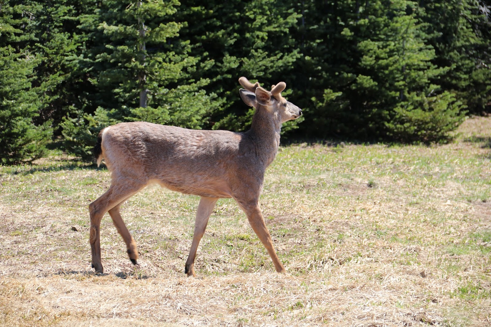
You can almost touch them
After walking around the parking lot area it was time to make the hike up the steep trail to the top of Hurricane Ridge.

About half way up and looking back we see this

Looking up the hill we see this. Can the old man make it?

This is the view from the top of Hurricane Ridge

Proof the old man made it to the top
Saturday, June 16, 2018
Spruce Goose (Hughes H-4 Flying Boat)
Since becoming aware of the Spruce Goose as a young man I have wanted to see it up close. That wish came true on Thursday when Pam, Joan, Rich, and myself traveled to the Evergreen Aviation & Space Museum in McMinnville, OR. The plane was moved there in 1992 on a 138 day, 1,055 mile journey that was completed on February 27,1993. When planning this trip I made sure to add the museum to the list of things to do while in Oregon.
The name Spruce Goose was given to the plane by the news media and Howard Hughes hated it. In fact, the majority of the plane is constructed of birch, not spruce. The Spruce Goose has the longest wingspan of any plane ever to fly and the fuselage is roughly the size of a 747. There is a plane under construction by Stratolaunch Systems Corporation scheduled to fly in 2019 that will have a longer wingspan.
https://en.wikipedia.org/wiki/Stratolaunch_Systems#Carrier_aircraft
The Spruce Goose joints were nailed together with glue and the nails removed after the glue set. That was done to keep the weight down and there must have been a million nails in that puppy. The photo below is one of the joints exposed where a second door was cut to make ingress/egress practical in the museum. The green area is painted wood and the skin of the fuselage is birch plywood. I suspect the hole is where a nail was removed.

Notice hole in wood joint
It is difficult to get a sense of how large this plane is from photographs but maybe the following photos will help.

Entry doors. Notice man up on landing

Spruce Goose in the museum
When you enter the plane and turn to the right you can see down the fuselage. In the following photo the manikin in the photo is 6 feet and 1 inch tall. The fire suppression system was added to the aircraft after it was placed in storage. After the flight in 1947 Hughes built a special climate controlled hanger to house the plane and maintain a 300 man crew of workers to maintain the plane at an annual cost of one million dollars. The crew was reduced to 50 in 1962 and then disbanded after his death in 1976.

Looking down the fuselage to the tail
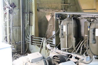
Entering the plane and turning to the left you see the area under the cockpit. This was the first plane to use hydraulics for control and the large electric motors, pumps, and fluid reservoirs as well as an electrical control center are located in this area.

The area under the cockpit

Electrical control panel

Hydraulics pumps
Hydraulics lines and reservoirs

Nose section beneath cockpit
Also located in this area are two radio antennas and Hughes on personal air filtration system. Because the fuselage is constructed of wood the radio antenna can be located inside. It is well known that Hughes was a germaphobe and the air filtration system was installed supplying filtered air directly to the pilot's seat.

One of two radio antenna

Air filtration system

The tube behind my head is the filtered air supply for Howard
When the Spruce Goose was moved to Oregon it had to be partially disassembled. It was during the disassembly that many beach balls were discovered inside the pontoons at the end of each wing. Hughes did not like to take chances and was worried about the pontoons springing a leak. He saw a beach ball and knew that was the solution he needed. He instructed his men to find as many beach balls as they could and they were filled with air and placed inside the pontoons. He also stationed eight men with fire extinguishers inside the wings behind each of the eight engines just in case the exhaust from an engine caught the wing on fire.

There was a pontoon under each wing. The plane is a boat.

Some of the beach balls found in the pontoons.
Notice the ladder in the photo below. That is where Howard Hughes climbed up to a hatch that opens on top of the aircraft He had a platform to stand on where he could direct the tow out of the hanger and into the bay. He is visible in the following youtube video doing just that.
A few more links of interest:

Rich is looking out into one of the wings.
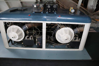
Going up to the cockpit area we find lots of equipment. Two small aircraft engines are used to run generators to provide electrical power for the aircraft. The propellers are missing and the crew had to use special cranks to start the engines. It must have been noisy inside the cockpit.

Electrical power generation by two aircraft engines attached to generators.

The area behind the cockpit.
The windows on the left of the Assistant Flight Engineers Station were installed after the plane became available for public viewing in California. The public was not allowed to enter the aircraft and a platform built to allow them to peer in thru the windows.

Assistant Flight Engineers Station

More monitoring equipment
The flight engineer had to synchronize all eight engines from the panel shown in the photo below. The Spruce Goose was powered by eight 3000 horsepower Pratt and Whitney R-4360 engines. The engines were air cooled radial, piston engines with 28 cylinders, four rows of seven, with 56 spark plugs running from seven magnetos. Each engine consumed 109 gallons of fuel per hour at cruise speed.

Flight Engineers Station

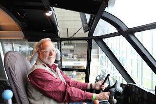
Pilots seat where Howard Hughes sat

Your flight crew
Subscribe to:
Comments (Atom)